Progress October 2020
Walther Camaro
Post-doc Researcher, University College Cork
When seeking to understand the relationship between wild birds and natural environments, it is essential to identify the main characteristics and dynamics of habitats in which birds meet all their necessities for survival: food, water, shelter and nesting areas. In addition, migratory birds change habitats seasonally, seeking out similar habitats that meet their needs at different times of the year.
The ECHOES project will study the characteristics and dynamics of key habitats along the Irish Sea coastlines, where the presence of Eurasian Curlew and Greenland White-fronted Goose (GWFG) is recurrent during winter. They migrate here to find habitats that meet their needs – such as mudflats and saltmarshes.
To understand the distribution and location of these habitats in Ireland and Wales, we will generate habitat and land cover maps through open source Earth Observation imagery. Vegetation data collected in the field surveys (by Work Package 4) will be used to support and confirm the information inferred from the Earth Observation sources. In addition, these maps will be compatible with the Species Distribution Modelling (SDM) activities from Work Package 3, developed with the aim to understand and predict the distribution of the species in the study areas.
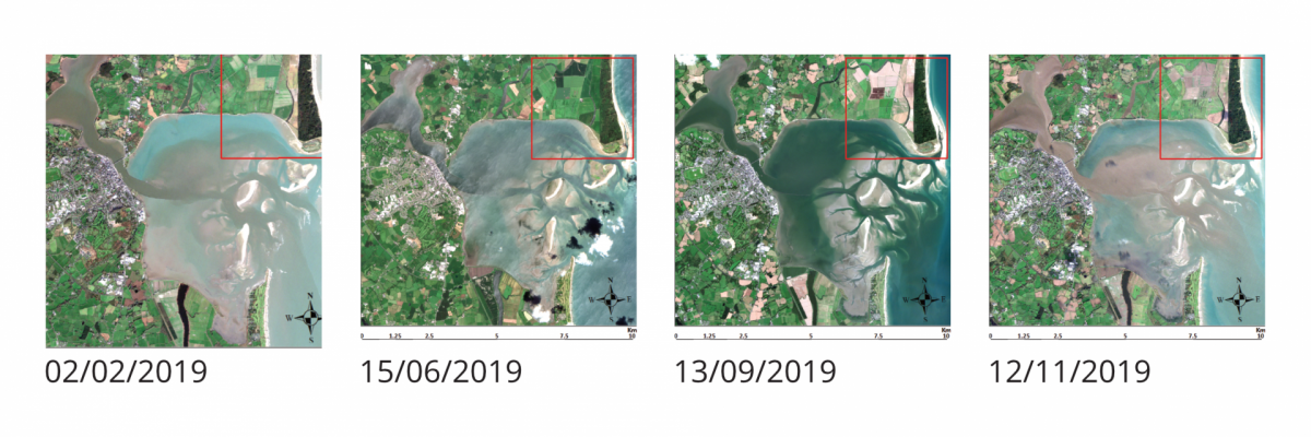
A good example of open source Earth Observation imagery are the Sentinel-2 images generated by the Copernicus Programme (managed by the European Commission and the European Space Agency). These images have a spatial resolution of 10 m, which allows for plenty of detail. We can see the distribution of habitats in coastal areas, where birds such as Curlews and GWFG are spending their winters.
The images below are Sentinel-2 products in different seasons during the 2019. They show the area of Wexford Wildfowl Reserve located in Co. Wexford on the East Irish coast. These images are useful to classify different types of habitats, and to identify the changes and dynamics of the vegetation during the year.

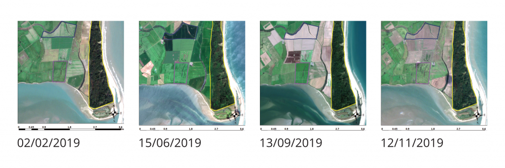
By zooming over the red square in each one of the images, it is possible to identify different types of habitats and how they change over the year. Some of these habitats are visited by Curlews and GWFG during the winter.
The yellow square (image below) could be classified as a ‘forest class’, presenting a similar pattern over different periods of the year. Most of the remaining land areas could be ‘grasslands’ or ‘pastures’, but with some different dynamic over the year. For example, the grasslands inside the blue shape change during the year due to cutting practices during the summer months. The grasslands where the cutting activities are identified are classified as ‘Improved Grasslands’ and are normally used for grazing. The grasslands with little change (purple square) are classified as ‘Unimproved Grasslands’ and considered as key habitats for migratory bird species during the winter.
The team in charge of the habitat mapping activities and the team in charge of the SDM and the field survey activities are currently discussing which key habitats that will need special attention during the habitat classification process, and how the information collected during the field surveys will support the habitat mapping activities.